
 Email Alerts
 RSS
RSS
Characteristics of storm surge water level and empirical forecasting at the Pearl River Estuary
-
摘要:
珠江河口受强台风影响频次较高,地处粤港澳大湾区核心区域,经济发达,风暴潮灾害通常给其造成严重损失。基于珠江河口典型水文站澳门内港站近50年长序列潮位资料,分析认为澳门内港站45%的年极值潮位是受台风影响导致,实测潮位极值发生在天文高潮位前后1 h内的概率约为82%,而增水极值与天文潮极值相位呈现较为明显的非均匀双峰分布,增水峰值发生在天文潮高潮位的频率仅5%。台风路径及登陆点对风暴潮增水的数值、持续时间等特征要素均有较大影响。西北向和西进型路径台风造成风暴潮增水较大且占比多,造成超30 cm增水的次数约占台风影响总次数的90%。当内港站位于台风的左半圆时增水量值相对较小;当内港站位于台风右半圆,增水幅度相对更大。同时存在登陆点越靠西,风暴潮增水持续时间更长、增水幅度越小的趋势。本研究还建立了风暴潮增水与台风强度、路径、登陆点的极值增水预报公式,拟合值与实测值的拟合度高。研究结果可为区域风暴潮预报及灾害防控提供参考。
Abstract:The Pearl River Estuary, located in the core area of the Guangdong-Hong Kong-Macao Greater Bay Area, is frequently affected by strong typhoons. As an economically developed region, it often suffers severe losses from storm surge disasters. Based on nearly 50 years of long-term tidal data from the Macau Inner Harbor station, a typical hydrological station in the Pearl River Estuary, this study analyzes that 45% of the annual extreme water levels at the Macau Inner Harbor station are caused by typhoon events. The probability of extreme water levels occurring within 1 hour before and after the astronomical high tide is approximately 82%. The extreme water level distribution shows a distinct non-uniform bimodal pattern, with the peak occurring in only 5% of the cases coinciding with the astronomical high tide. The path and landfall location of typhoons have significant impacts on the characteristics of storm surge, including its magnitude and duration. Typhoons with a northwestward or westward path cause larger storm surge and account for the majority of cases with over 30 cm of storm surge, approximately 90% of the total. When the Macau Inner Harbor station is located in the left semicircle of a typhoon, the storm surge is relatively small, while it is larger when the station is in the right semicircle. Moreover, a trend is observed where storm surge duration is longer and surge magnitude is smaller when the landfall point is closer to the west. Empirical formulas for extreme surge forecasting considering typhoon intensity, path, and landfall location are established and show a high degree of fitting with the observed values. This study provides valuable references for regional storm surge forecasting and disaster prevention and control.
-
风暴潮灾害在世界自然灾害中居首位,国际自然灾害防御和减灾协会 [1]曾统计分析指出,从1875年以来,全球范围直接和间接的风暴潮经济损失超过1 000亿美元;Shi等[2]统计研究了中国沿海地区风暴潮,发现近65年来风暴潮发生频率呈明显上升趋势,其中广东沿海是中国沿海台风暴潮最严重的地区[3]。珠江河口平均每年有5.8个热带气旋影响该地区[4]。董剑希等[5]以1949年以来广东省10个典型验潮站开展了风暴潮时空分布分析,珠江口为风暴潮灾害频发区,平均每年1.5次。受气候变化的影响,珠江河口强台风次数呈增加趋势,2017年第13号台风“天鸽”使珠江河口核心城市澳门遭受重创;2018 年第22 号台风“山竹”期间珠江河口多个潮位超历史极值、最大增水达3.37 m[6],并造成较大经济损失[7]。因此有必要对珠江河口风暴潮灾害特性及预报开展持续性研究。
台风发生时间、强度、路径、登陆点均会影响风暴潮增水数值,邰佳爱等[8]对强台风0814(黑格比)和9615(莎莉)台风影响下的珠江河口风暴潮超高潮位进行了分析;罗志发等[9-10]建立了粤港澳大湾区风暴潮数值模型,分析了不同台风登陆点对风暴潮增水的空间分布的影响,发现当台风在珠江河口西岸登陆,距离台风登陆点约2.5倍最大风速半径的位置可产生较大的增水值;胡仕焜等[11]利用ADCIRC+ SWAN 模型分析了珠江河口区风暴潮增水过程非线性叠加效应,显示在珠江口西岸登陆台风带来的增水最大,其风暴潮-天文潮的非线性效应最大;刘文龙等[12]研究了不同台风移速下增水的响应,认为低移速台风影响时间更长。风暴潮预报是减轻风暴潮灾害的重要技术手段,主要分为数值预报和经验预报[13]。李未等[14]利用BP人工神经网络,建立了珠江河口两测站台风暴潮和天文潮的综合增水效应预报模型;魏晓宇等[15]采用杰氏风暴潮经验预报方法对珠海地区的台风增水进行了试报;叶荣辉等[16-17]系统研究了珠江河口台风特征、开展了风暴潮数值模拟研究,并初步构建了珠江河口风暴潮数值模拟及预报系统;高娜等[18]采用最大风速表征台风强度、结合距离变量对增水进行拟合,得到台风影响增水的经验关系模型。
基础资料既是风暴潮数学模型建立的数据来源,也是分析研究风暴潮特征和开展预报的重要手段,同时经验预报作为单站预报的快速预报模式,具有针对性强、计算快、使用便捷度高的优势,在风暴潮预报中有着不可替代的作用。目前珠江河口基于历史观测资料的统计分析多关注风暴潮的时空分布特征[19-21],在探讨风暴潮与潮汐、台风路径、登陆点等关系时多采用数值模拟的方式,而基于历史数据的统计分析较少。本文以位于珠江河口伶仃洋湾口的澳门内港长期潮位站作为代表站,对站点近50年的原始观测潮位开展调和分析,剥离天文潮潮位,并通过统计分析与数据挖掘,分析风暴潮增水与相关台风路径、登陆点、中心气压、潮汐的关系,并利用多元非线性回归统计方法建立风暴潮极值增水与相关参数的函数关系式。
1. 研究区域及数据来源
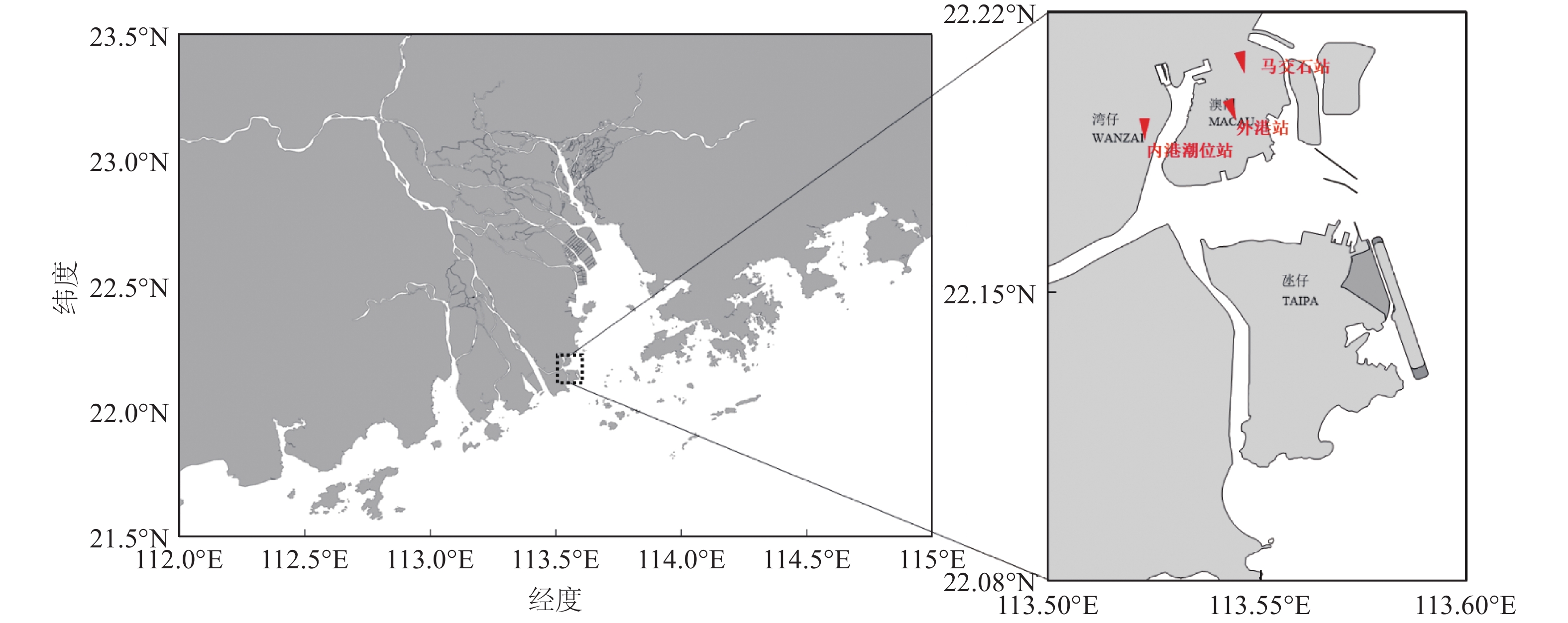
选取珠江河口伶仃洋湾口的澳门内港站(图1)作为代表站点,澳门潮位观测时间为1925年至今,本文选用1966—2018年共53年的实测潮位数据开展分析,其中1966—1982年12月潮位数据为马交石站、1983年1月至1984年4月为外港验潮站、1984年4月至2018年为内港潮位站,本次分析已通过潮位相关分析将马交石站及外港站数据统一到内港站,潮位数据采用基面为澳门平均海平面。台风资料采用中国气象局热带气旋资料中心发布的热带气旋最佳路径数据集数据(tcdata.typhoon.gov.cn),包含热带气旋中心每6小时的坐标位置及强度信息。风暴潮潮位是由天文潮和风暴潮增水叠加而成,本次研究采用T_TIDE程序[19]对内港潮位过程进行调和分析,用实测潮位过程减去调和分析的天文潮过程得到风暴潮增水过程。
![]() 图 1 澳门内港潮位站点地理位置示意Figure 1. The geographic location of the Macau inner harbor tidal stations
图 1 澳门内港潮位站点地理位置示意Figure 1. The geographic location of the Macau inner harbor tidal stations2. 研究内容
2.1 澳门内港站潮位变化趋势
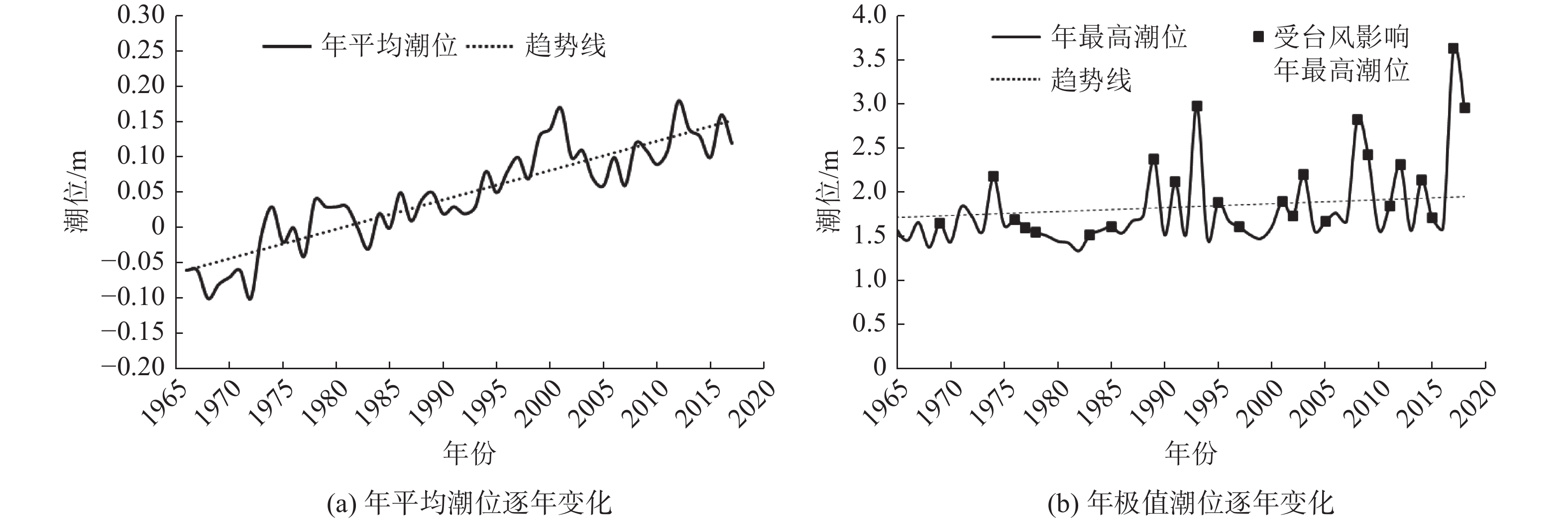
从内港站年平均与极值潮位变化趋势可知,澳门内港年平均潮位呈上升趋势(图2),大约每10年抬升4 cm,增幅趋势明显。其潮位逐年抬升与多项因素相关,已有文献[22]指出1980—2022年广东省沿海海平面上升率为3.5 mm/a,同时因澳门沿岸填海和围垦工程建设、上游水土流失等多方面因素导致澳门内港年平均潮位的抬高。根据近50年来的实测年极值潮位统计,53个年极值潮位大多数发生在大潮期间,45%的年极值潮位由台风影响导致,且年最高潮位也呈抬升趋势。
![]() 图 2 澳门内港潮位站特征潮位逐年变化Figure 2. Annual variation of characteristic water levels at the Macau inner harbor tidal stations
图 2 澳门内港潮位站特征潮位逐年变化Figure 2. Annual variation of characteristic water levels at the Macau inner harbor tidal stations2.2 风暴潮与潮汐遭遇分析
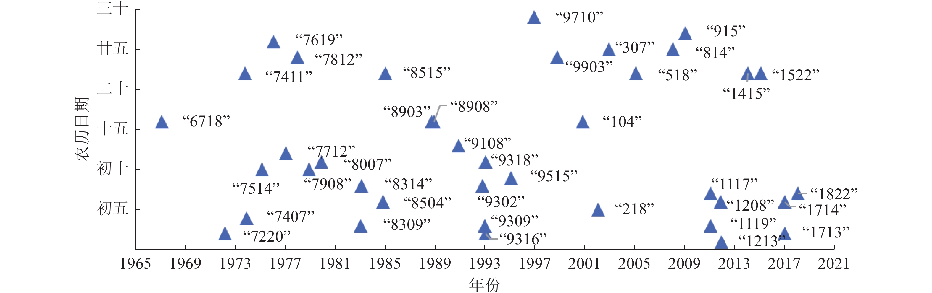
从半月潮周期与月潮周期来看,风暴潮与天文潮大小潮的遭遇可视为相互独立,统计各场次台风暴潮增水极值对应农历日期(图3),1967—2018年间的30多场台风导致内港站发生风暴增水,发生在大潮、中潮和小潮期的比例分别为31%、36%和33%。其中:大潮为廿九至初三、十五至十八,小潮为初七至初十、廿一到廿四,其余为中潮。从对珠江河口的危害性来说,当强台风遭遇天文潮大潮高高潮,产生的影响较为严重,如2017年第13号台风及1993年第16号台风;但中潮期间由强台风引发的增水依旧不可忽视,如2008年第14号台风和2012年第8号台风。在30多场台风增水数据统计中,发生在中潮期的平均极值增水为1.26 m,高于大潮期平均极值增水值1.15 m和小潮期平均极值增水值1.16 m,由于中潮期间低高潮和高高潮之间差距不大,即便台风与低高潮叠加造成的潮位也同样值得警惕。
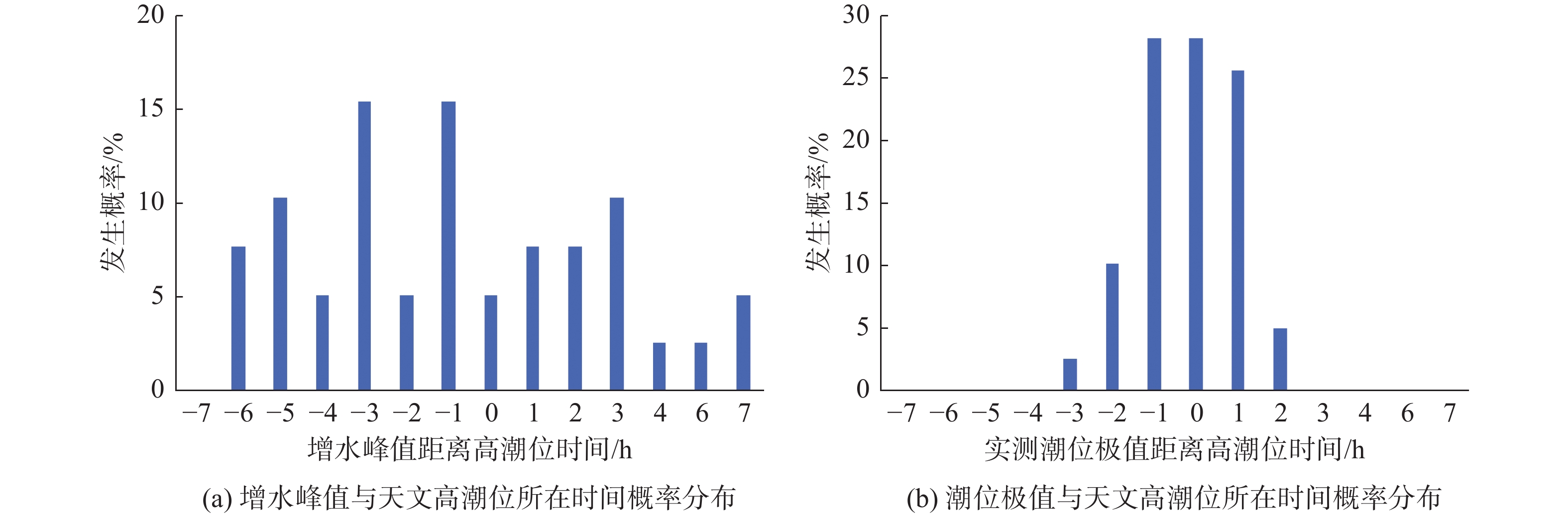
从日潮周期看,实际潮位过程、风暴潮增水过程与天文潮存在较为明显的相互作用,比较实测潮位极值与天文高潮位所在时间(图4),实测潮位极值发生在天文高潮位前后1 h内的概率为82.05%,最高潮位明显受到天文潮位的影响。而增水极值与天文潮极值所在时间差值呈现了较为明显的非均匀双峰分布,增水峰值发生在天文潮高潮位的频率仅5.13%,在涨潮期的概率总体要大于发生在落潮期的概率,在天文潮高潮位前后3 h均存在一个较为明显的峰值,非线性相互作用在涨潮、落潮期间更显著。
![]() 图 4 增水峰值与实测潮位极值与天文高潮位的时间Figure 4. Timing of peak surge and extreme tidal levels relative to astronomical high tides
图 4 增水峰值与实测潮位极值与天文高潮位的时间Figure 4. Timing of peak surge and extreme tidal levels relative to astronomical high tides2.3 澳门内港站风暴潮增水规律分析
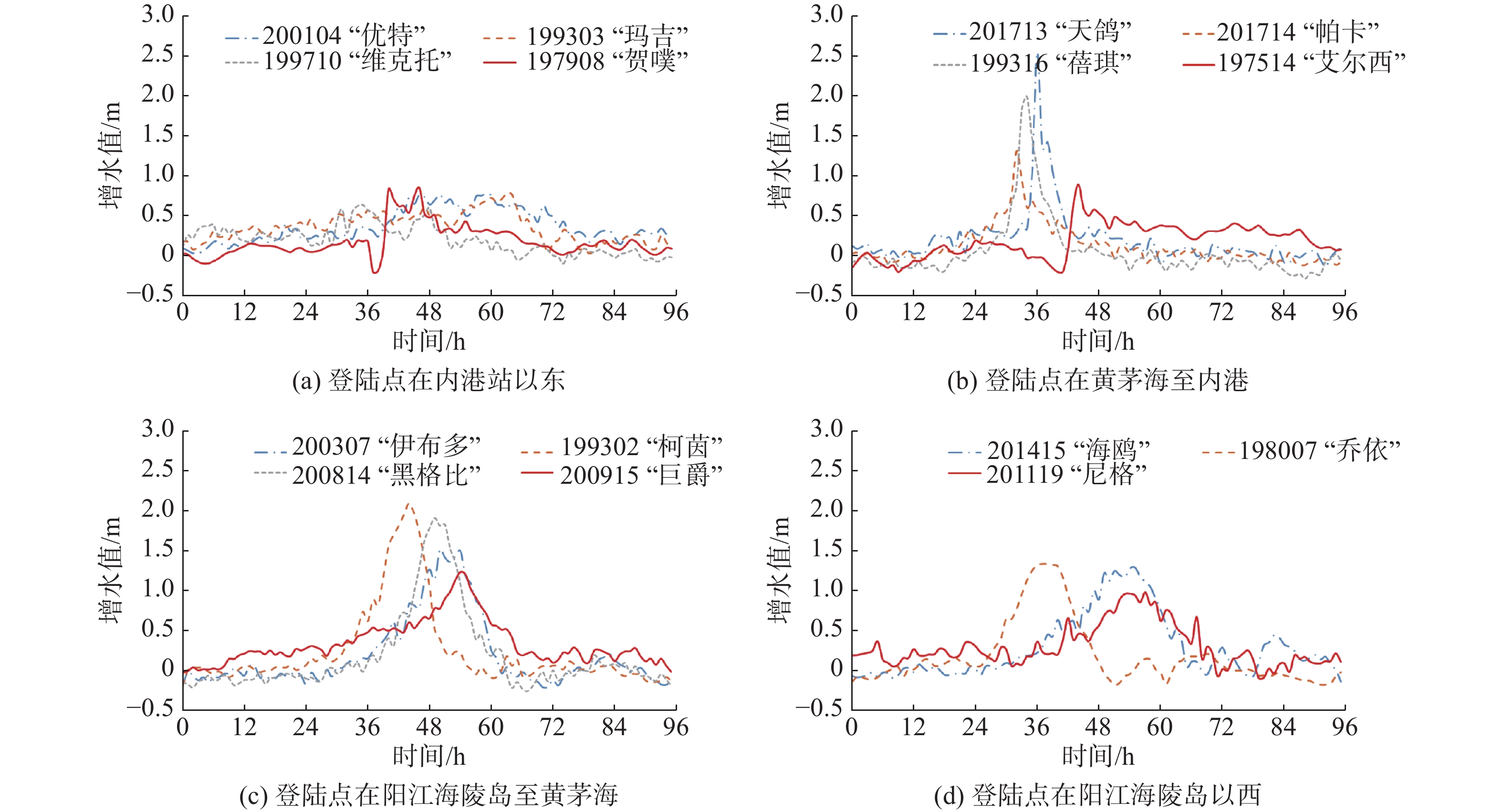
台风移向、路径、强度、持续时间对风暴潮的产生及其潮位高低起关键性作用[11],本次研究归纳台风期间30多次大于50 cm的风暴增水过程线,总结风暴潮增水规律。
2.3.1 风暴潮增水与台风强度的关系
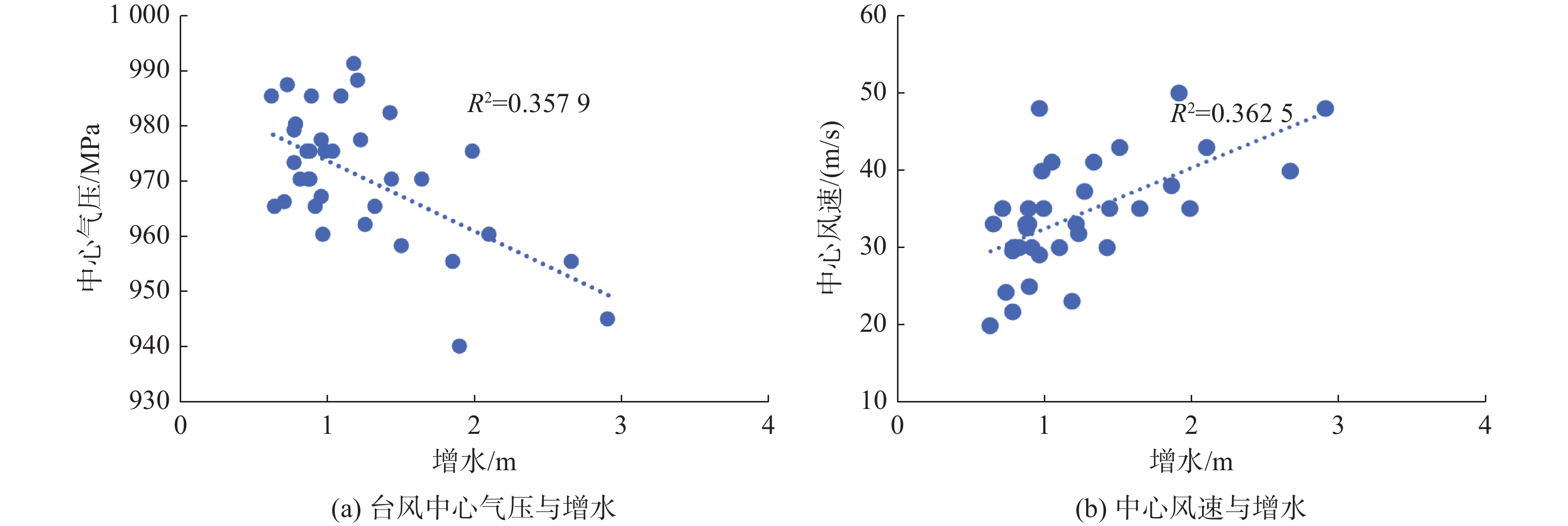
统计了台风登陆前6 h台风中心气压、中心风速与风暴潮增水之间的关系(图5)。可见:总体上台风中心气压与风暴潮增水呈负相关关系,台风中心气压越低、引起的风暴潮增水越大;而台风中心风速与风暴潮引起的增水呈正相关关系,强度越大、风暴潮增水越大。
![]() 图 5 台风中心气压和风速与增水关系Figure 5. Relationship between typhoon center pressure, wind speed, and surge
图 5 台风中心气压和风速与增水关系Figure 5. Relationship between typhoon center pressure, wind speed, and surge2.3.2 风暴潮增水与移行路径的关系
影响珠江河口的登陆热带气旋,移行路径上可分为3类典型路径,分别为西进或西北型、北上型和其他路径。经统计珠江河口以西进型或西北型热带气旋频数最多,占比63.87%,北上型占比14.01%,其他路径类型为22.12%[4]。而从引起澳门内港站风暴潮增水的频次来看(表1),在增水超过50 cm的30多场台风内,西北型或西进型的占比总和达89.7%,北上型和其他路径类型仅占10.3%。
表 1 不同路径台风占比及增水情况Table 1. Proportions and surge conditions of typhoons with different paths台风路径 数量/个 占比/% 平均极值增水/m 最大极值增水/m 西北型 30 76.9 1.33 2.91 西进型 5 12.8 0.80 0.89 北上型 3 7.7 0.73 0.78 其他 1 2.6 0.65 0.65 从造成极值增水的数值看,西北型台风造成的极值增水平均值为1.36 m,相比较而言西北型的台风更易造成澳门附近水域更大的增水。当移行路径为西北型时,珠江河口主要受到气旋右侧的偏东到东南风为主,内港站所在伶仃洋西岸为利于海水向岸堆积的风向,而北上型台风数量较少,大多在内港站以东登录,例如2013年第11号台风尤特登录时内港站风向以不利于增水的偏北风为主,而西进型在逐渐靠近岸边的过程中,潮位监测站主要受到热带气旋左侧的西向及偏北风作用。因此,西进型、北上型和其他路径台风造成的极值增水相对较小,平均值分别为0.80、0.76和0.65 m。
2.3.3 风暴潮增水与台风登陆点的关系
当台风登录点在内港站以东,即站点位于台风的左半圆,通常台风登陆的左半圆风力小、范围窄、持续时间短。此时虽然也有风暴潮增水,但是量值相对较小。经统计,当内港站位于台风的左半圆,如2001年4号台风“尤特”、1999年第3号台风“玛吉”、1997年第10号台风“维克托”、1979年第8号台风“贺噗”来袭时内港站均位于台风左半圆。几个台风引起的最大增水均不超过0.83 m,平均增水值为0.76 m,同时从台风增水过程来看,平均增水超过0.5 m的时间为14.6 h(表2),其增水过程持续时间相对较长。
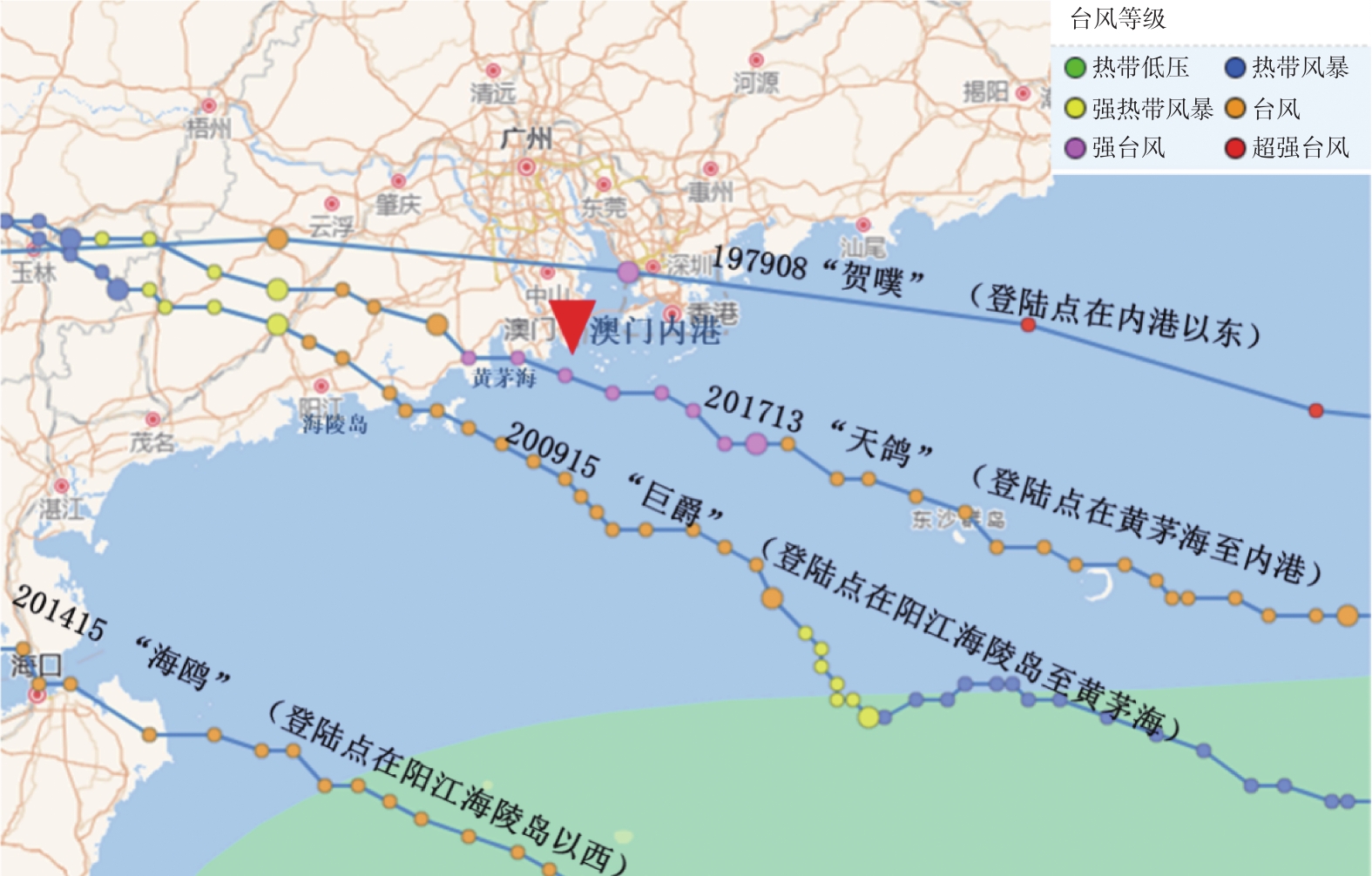
表 2 台风登录点与极值增水值、持续时间关系Table 2. Relationship between typhoon landfall points, extreme surge values, and duration台风登陆点 平均极值增水/m 最大极值增水/m 增水持续时间/h 内港以东 0.74 0.83 14.60 黄茅海至内港 1.50 2.67 9.50 阳江海陵岛至黄茅海 1.35 2.91 17.18 阳江海陵岛以西 1.03 1.51 20.38 当登陆地点在黄茅海以东内港以西,即内港站位于台风的右半圆,台风袭击时其右半圆海岸吹东风到东南风,伶仃西岸风向向岸且风力大、持续时间长,且伶仃洋的喇叭形河口湾更容易堆积壅高形成较大增水,不同路径典型台风与内港站位置示意见图6。同时当登陆点在江门广海湾以东,距离澳门内港较近,由于澳门水道水面较宽(宽度为1 750~2 500 m),其出口为东至东南向,大量海水随强劲风速从伶仃洋直接涌入澳门水道,进入澳门水道的潮流,一部分继续向东沿洪湾水道上溯,一部分进入湾仔水道。由于洪湾水道全长11 km,与磨刀门水道相通,河宽平均仅为440 m,因此大部分从澳门水道涌入的风暴潮流沿湾仔水道北上,而湾仔水道为一盲肠河段,总长约4 km,河宽大部分为500~800 m,大量海水涌入湾仔水道造成该水域水位急剧升高,增水和退水时间相对较短,其中201713“天鸽”台风期间内港站在2 h内增水2.2 m,涨水速度极快,同时退水速度相对也较快,经6 h退至正常潮水位,若风力和气压较大时,造成的增水幅度较大。当登陆地点在黄茅海以东,平均增水超过0.5 m的时间为9.5 h。
![]() 图 6 不同路径典型台风与内港站位置示意Figure 6. Schematic of typical typhoon paths and the location of the inner harbor stations
图 6 不同路径典型台风与内港站位置示意Figure 6. Schematic of typical typhoon paths and the location of the inner harbor stations当登陆地点在阳江海陵岛至黄茅海,距离澳门内港相对较远,受持续东南向风的影响,其增水及退水时间相对登陆点在广海湾以东的台风要缓慢,平均增水超过0.5 m的时间为17.18 h,典型风暴潮增水过程见图7。200814“黑格比”台风路径为典型的西北向路径,登陆地点在广东茂名,珠江河口处于台风行进路线的右半圆区,受持续东南向风的影响,珠江河口一直处于相对缓慢增水过程中。“黑格比”台风从开始发生风暴潮增水至达到最大增水,时间普遍为7~8 h。
当登陆点位于阳江海陵岛以西则引起的增水幅度相对较小,增水时间持续更长,平均增水超过0.5 m的时间为20.38 h。
2.3.4 风暴潮增水与天文潮的关系
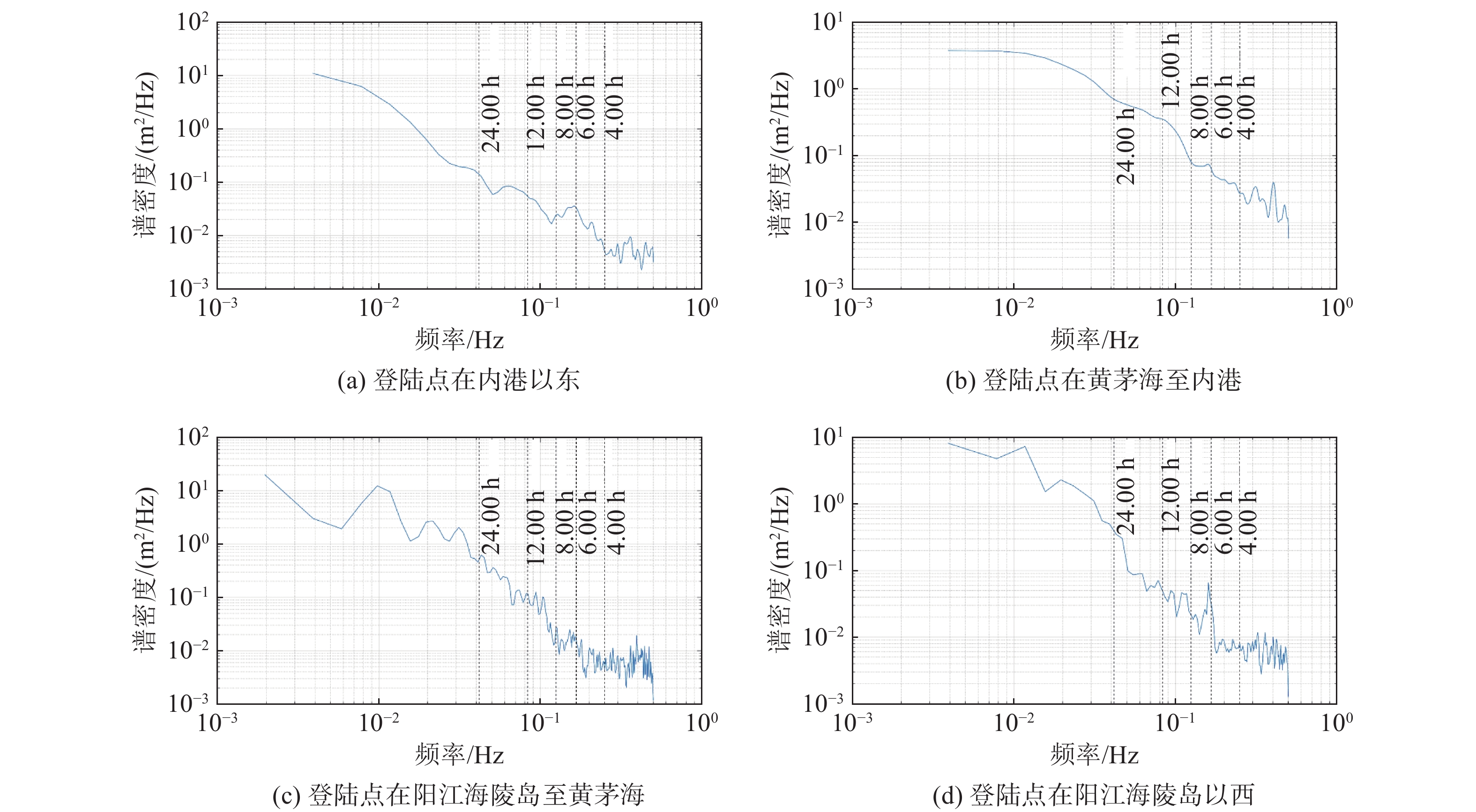
采用功率谱方法对风暴潮增水过程开展分析。若天文潮和风暴潮本身相互独立,故如非线性相互作用可以忽略,则非潮余水位的功率曲线较为平缓;如非线性相互作用显著,则非潮余水位功率谱会在特定的潮汐频率区间内较为集中[23]。在功率谱图中,出现的峰值表示该特定频率的能量或功率是显著的。如果信号中有1个强烈的周期性成分,那么在该频率上会出现1个显著的峰值。从功率谱图(图8)可以看到,不同登陆点的增水过程均在高频分潮6 h的频率区间出现小幅抬升,从显著程度来看,登陆点在阳江海陵岛以西和内港站以东受潮汐周期影响更为明显。
![]() 图 8 不同登陆点下增水功能谱分析Figure 8. Spectral analysis of surge function for different landfall points
图 8 不同登陆点下增水功能谱分析Figure 8. Spectral analysis of surge function for different landfall points2.4 风暴潮极值增水统计预报公式
风暴潮受诸多难以精确表达因素的影响,很难给出便于计算的、准确的数学表达式,只能选取影响相对较大并且便于使用的因子近似地进行计算。本文采用杰氏风暴潮预报方法,选用台风强度及位置这2个因素对风暴潮最大增水进行拟合。
单站最大增水的经验预报公式如下:
$$ \Delta H=A \Delta P_0\left(1-\exp \left(-r_0 / r\right)\right)+C$$ (1) 式中:$\Delta H $为最大增水值(cm);ΔP0 = P∞−P0,P∞为正常气压,P0为台风中心气压(hPa);r0为台风最大风速半径(最大风速处与台风中心的距离),其中最大风速半径与气压采用气压与最大风速半径对应表进行查表计算[24];r为本站最大增水发生时,台风中心到测站的距离(纬距);A、C为待定系数。
同时考虑到风暴潮增水也与台风路径密切相关,本次统计预报将台风类型分为3类:一是测站位于台风左半圆;二是测站位于台风右半圆但台风为北上型,其增水以气压效应增水为主;三是测站位于台风右半圆,但台风为西北向及西向,此时增水与台风气压、风速均有关联。在这3种类型的基础上,利用多元非线性回归统计方法,基于不同类型的台风给出不同的风暴潮增水公式如下:
测站位于台风左半圆经验预报公式:
$$ \Delta H=0.004\;3 \Delta P_0\left(1-\exp \left(-r_0 / r\right)\right)+0.697\;2$$ (2) 测站位于台风右半圆经验预报公式:
$$ \Delta H=\left\{\begin{array}{ll} 0.187\;7 \Delta P_0\left(1-\exp \left(-r_0 / r\right)\right)-0.061\;8 ,&当台风为北上型\\ 0.054\;1 \Delta P_0\left(1-\exp \left(-r_0 / r\right)\right)+0.773\;9,&当台风为西北型 \end{array}\right. $$ (3) 当台风为北上型,即台风路线为N向和NNW向时,其增水主要为气压效应引起的增水;当台风为西北向时,也是对澳门附近水域影响最大的类型,其增水与台风气压、登陆点等关系更为密切。
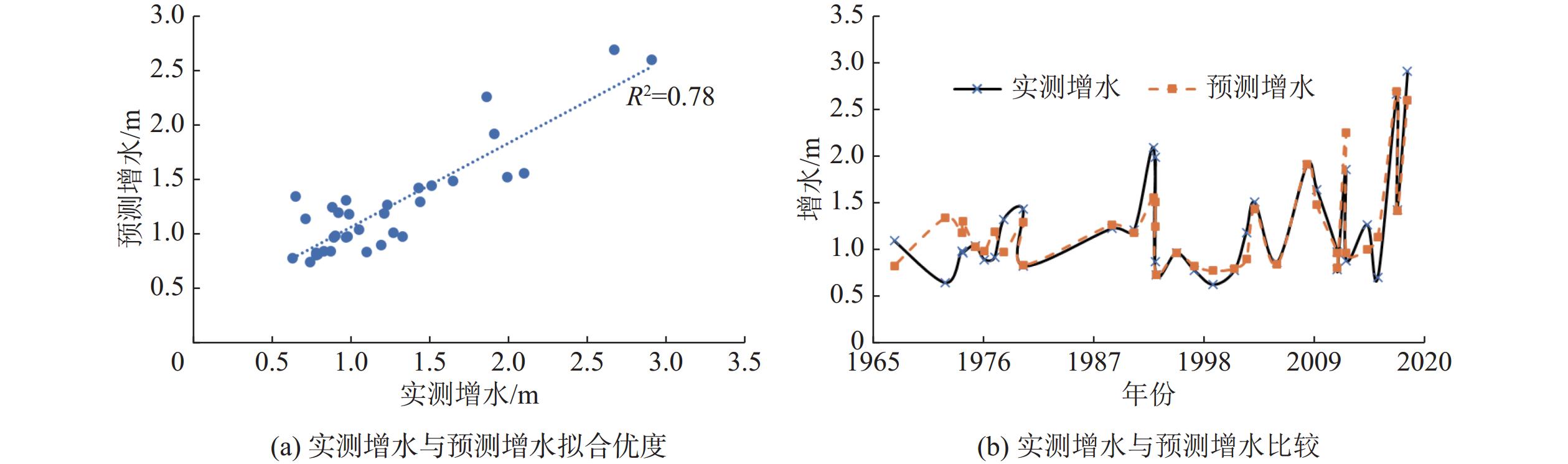
经验证,风暴潮极值增水拟合值与实测值的对比见图9,拟合优度R2为0.78,标准差为0.22 m。总体而言,误差较大的数据出现在1965—1980年,由于其台风数据资料缺乏,加之地形改变、工程建设等原因,导致其误差较大;而1980年后随着台风数据丰富,误差相对较小。同时从前述研究可知,风暴潮增水与天文潮之间存在较强的非线性作用,而本次曲线拟合忽略了风暴潮增水引起潮位增大的非线性叠加作用来剥离风暴潮增水和天文潮,也是本次风暴潮经验预报拟合的误差来源。
3. 结 语
本文对珠江河口伶仃洋湾口澳门内港站近50年长序列潮位资料开展分析,45%的年极值潮位是受台风影响导致。其中风暴潮与天文潮在日潮周期尺度上存在明显的相互作用,实测潮位极值发生在天文高潮位前后1 h内的概率为82.05%,而增水极值与天文潮极值所在时间差值呈现较为明显的非均匀双峰分布,增水峰值发生在天文潮高潮位的频率仅为5.13%。
风暴潮增水整体上与台风中心气压呈负相关、与台风强度、风速呈正相关;本研究引发澳门内港增水超过50 cm的30多场台风中,西北型或西进型的占比总和为89.7%;从台风登陆点看,当内港站位于台风的左半圆时增水量值相对较小,当其位于台风右半圆则增水幅度相对较大。同时存在登陆点越靠西,风暴潮增水持续时间更长、增水幅度越小的趋势。从功率谱来看,不同登陆点的增水过程在6 h的频率区间功率较为集中,这表明增水过程均受到了潮汐周期的影响。
本次统计通过根据不同类型的台风给出不同的风暴潮增水公式,风暴潮极值增水拟合值与实测值的拟合优度R2为0.78,标准差为0.22 m。本风暴潮预报模型可为区域风暴潮灾害防控提供科学参考。
-
![]()
图 1 澳门内港潮位站点地理位置示意
Figure 1. The geographic location of the Macau inner harbor tidal stations
![]()
图 2 澳门内港潮位站特征潮位逐年变化
Figure 2. Annual variation of characteristic water levels at the Macau inner harbor tidal stations
![]()
图 4 增水峰值与实测潮位极值与天文高潮位的时间
Figure 4. Timing of peak surge and extreme tidal levels relative to astronomical high tides
![]()
图 5 台风中心气压和风速与增水关系
Figure 5. Relationship between typhoon center pressure, wind speed, and surge
![]()
图 6 不同路径典型台风与内港站位置示意
Figure 6. Schematic of typical typhoon paths and the location of the inner harbor stations
![]()
图 8 不同登陆点下增水功能谱分析
Figure 8. Spectral analysis of surge function for different landfall points
表 1 不同路径台风占比及增水情况
Table 1 Proportions and surge conditions of typhoons with different paths
台风路径 数量/个 占比/% 平均极值增水/m 最大极值增水/m 西北型 30 76.9 1.33 2.91 西进型 5 12.8 0.80 0.89 北上型 3 7.7 0.73 0.78 其他 1 2.6 0.65 0.65  下载: 导出CSV
表 2 台风登录点与极值增水值、持续时间关系
Table 2 Relationship between typhoon landfall points, extreme surge values, and duration
台风登陆点 平均极值增水/m 最大极值增水/m 增水持续时间/h 内港以东 0.74 0.83 14.60 黄茅海至内港 1.50 2.67 9.50 阳江海陵岛至黄茅海 1.35 2.91 17.18 阳江海陵岛以西 1.03 1.51 20.38
下载: 导出CSV
-
[1] MURTY T S, VENKATESH S, DANARD M B, et al. Storm surges in Canadian waters[J]. Atmosphere-Ocean, 1995, 33(2): 359-387. doi: 10.1080/07055900.1995.9649537
[2] SHI X W, LIU S, YANG S N, et al. Spatial-temporal distribution of storm surge damage in the coastal areas of China[J]. Natural Hazards, 2015, 79(1): 237-247. doi: 10.1007/s11069-015-1838-z
[3] 甘申东, 章卫胜, 宗虎城, 等. 我国南海沿海台风风暴潮灾害分析及减灾对策[J]. 水利水运工程学报,2012(6):51-58. (GAN Shendong, ZHANG Weisheng, ZONG Hucheng, et al. Analysis of typhoon storm surge disasters along the South China coast and disaster prevention measures[J]. Hydro-Science and Engineering, 2012(6): 51-58. (in Chinese) doi: 10.3969/j.issn.1009-640X.2012.06.009 GAN Shendong, ZHANG Weisheng, ZONG Hucheng, et al. Analysis of typhoon storm surge disasters along the South China coast and disaster prevention measures[J]. Hydro-Science and Engineering, 2012(6): 51-58. (in Chinese) doi: 10.3969/j.issn.1009-640X.2012.06.009
[4] 叶荣辉, 戈军, 张文明, 等. 影响粤港澳大湾区的热带气旋统计分析[J]. 水利水电技术,2020,51(增刊1):37-43. (YE Ronghui, GE Jun, ZHANG Wenming, et al. Statistical analysis on impact from tropical cyclone on Guangdong-Hong Kong-Macao Greater Bay Area[J]. Water Resources and Hydropower Engineering, 2020, 51(Suppl1): 37-43. (in Chinese) YE Ronghui, GE Jun, ZHANG Wenming, et al. Statistical analysis on impact from tropical cyclone on Guangdong-Hong Kong-Macao Greater Bay Area[J]. Water Resources and Hydropower Engineering, 2020, 51(Suppl1): 37-43. (in Chinese)
[5] 董剑希, 李涛, 侯京明, 等. 广东省风暴潮时空分布特征及重点城市风暴潮风险研究[J]. 海洋学报,2014,36(3):83-93. (DONG Jianxi, LI Tao, HOU Jingming, et al. The characteristics of temporal and spatial distribution of storm surge in Guangdong Province and storm surge hazard study at Yangjiang City[J]. Acta Oceanologica Sinica, 2014, 36(3): 83-93. (in Chinese) DONG Jianxi, LI Tao, HOU Jingming, et al. The characteristics of temporal and spatial distribution of storm surge in Guangdong Province and storm surge hazard study at Yangjiang City[J]. Acta Oceanologica Sinica, 2014, 36(3): 83-93. (in Chinese)
[6] 刘士诚, 陈永平, 谭亚, 等. 珠江河网1822号台风“山竹”期间风暴增水模拟及特性分析[J]. 海洋预报,2021,38(2):12-20. (LIU Shicheng, CHEN Yongping, TAN Ya, et al. Storm surge simulation and characteristic analysis during typhoon “Mangkhut” 2018 in the Pearl River Estuary[J]. Marine Forecasts, 2021, 38(2): 12-20. (in Chinese) LIU Shicheng, CHEN Yongping, TAN Ya, et al. Storm surge simulation and characteristic analysis during typhoon “Mangkhut” 2018 in the Pearl River Estuary[J]. Marine Forecasts, 2021, 38(2): 12-20. (in Chinese)
[7] 广东省自然资源厅. 2018年广东省海洋灾害公报[EB/OL]. (2020-12-09)[ 2023-11-01]. https://nr.gd.gov.cn/zwgknew/sjfb/tjsj/content/post_3186929.html. (Department of Natural Resources of Guangdong Province. 2018 Bulletin of Marine Disasters in Guangdong Province [EB/OL]. (2020-12-09)[ 2023-11-01]. https://nr.gd.gov.cn/zwgknew/sjfb/tjsj/content/post_3186929.html. (in Chinese) Department of Natural Resources of Guangdong Province. 2018 Bulletin of Marine Disasters in Guangdong Province [EB/OL]. (2020-12-09)[ 2023-11-01]. https://nr.gd.gov.cn/zwgknew/sjfb/tjsj/content/post_3186929.html. (in Chinese)
[8] 邰佳爱, 张长宽, 宋立荣. 强台风0814(黑格比)和9615(莎莉)台风暴潮珠江口内超高潮位分析[J]. 海洋通报,2009,28(6):14-18. (TAI Jia’ai, ZHANG Changkuan, SONG Lirong. Super high water levels due to intense typhoons 0814 (Hagupit) and 9615 (Sally) in the Peal River Estuary[J]. Marine Science Bulletin, 2009, 28(6): 14-18. (in Chinese) doi: 10.3969/j.issn.1001-6392.2009.06.003 TAI Jia’ai, ZHANG Changkuan, SONG Lirong. Super high water levels due to intense typhoons 0814 (Hagupit) and 9615 (Sally) in the Peal River Estuary[J]. Marine Science Bulletin, 2009, 28(6): 14-18. (in Chinese) doi: 10.3969/j.issn.1001-6392.2009.06.003
[9] 罗志发, 黄本胜, 谭超, 等. 粤港澳大湾区风暴潮数值模型的建立与应用[J]. 广东水利水电,2020(11):58-63. (LUO Zhifa, HUANG Bensheng, TAN Chao, et al. Development and application of the storm surges numerical model around Guangdong-Hong Kong-Macao greater bay area[J]. Guangdong Water Resources and Hydropower, 2020(11): 58-63. (in Chinese) LUO Zhifa, HUANG Bensheng, TAN Chao, et al. Development and application of the storm surges numerical model around Guangdong-Hong Kong-Macao greater bay area[J]. Guangdong Water Resources and Hydropower, 2020(11): 58-63. (in Chinese)
[10] 罗志发, 黄本胜, 邱静, 等. 粤港澳大湾区风暴潮时空分布特征及影响因素[J]. 水资源保护,2022,38(3):72-79, 153. (LUO Zhifa, HUANG Bensheng, QIU Jing, et al. Spatio-temporal distribution characteristics and influencing mechanisms of storm surge in Guangdong, Hong Kong and Macao Greater Bay Area[J]. Water Resources Protection, 2022, 38(3): 72-79, 153. (in Chinese) doi: 10.3880/j.issn.1004-6933.2022.03.010 LUO Zhifa, HUANG Bensheng, QIU Jing, et al. Spatio-temporal distribution characteristics and influencing mechanisms of storm surge in Guangdong, Hong Kong and Macao Greater Bay Area[J]. Water Resources Protection, 2022, 38(3): 72-79, 153. (in Chinese) doi: 10.3880/j.issn.1004-6933.2022.03.010
[11] 胡仕焜, 刘丙军, 邱江潮, 等. 珠江河口区风暴潮增水过程非线性叠加效应研究[J]. 海洋科学,2023,47(1):1-12. (HU Shikun, LIU Bingjun, QIU Jiangchao, et al. Nonlinear effects of a storm surge in the Pearl River Estuary[J]. Marine Sciences, 2023, 47(1): 1-12. (in Chinese) HU Shikun, LIU Bingjun, QIU Jiangchao, et al. Nonlinear effects of a storm surge in the Pearl River Estuary[J]. Marine Sciences, 2023, 47(1): 1-12. (in Chinese)
[12] 刘文龙, 梁慧迪, 蒋茗韬, 等. 浙江沿海风暴潮增水对台风移速的响应研究[J]. 水利水运工程学报,2024(1):56-67. (LIU Wenlong, LIANG Huidi, JIANG Mingtao, et al. Study on the response of different moving speeds on storm surge in Zhejiang coastal waters[J]. Hydro-Science and Engineering, 2024(1): 56-67. (in Chinese) LIU Wenlong, LIANG Huidi, JIANG Mingtao, et al. Study on the response of different moving speeds on storm surge in Zhejiang coastal waters[J]. Hydro-Science and Engineering, 2024(1): 56-67. (in Chinese)
[13] 冯士筰. 风暴潮导论[M]. 北京: 科学出版社, 1982. (FENG Shizuo. Introduction to storm surge[M]. Beijing: Science Press, 1982. (in Chinese) FENG Shizuo. Introduction to storm surge[M]. Beijing: Science Press, 1982. (in Chinese)
[14] 李未, 王如云, 卢长娜, 等. 神经网络在珠江口风暴潮预报中的应用[J]. 热带海洋学报,2006,25(3):10-13. (LI Wei, WANG Ruyun, LU Changna, et al. Forecast of storm surge in Zhujiang River Estuary by means of artificial neural network[J]. Journal of Tropical Oceanography, 2006, 25(3): 10-13. (in Chinese) doi: 10.3969/j.issn.1009-5470.2006.03.002 LI Wei, WANG Ruyun, LU Changna, et al. Forecast of storm surge in Zhujiang River Estuary by means of artificial neural network[J]. Journal of Tropical Oceanography, 2006, 25(3): 10-13. (in Chinese) doi: 10.3969/j.issn.1009-5470.2006.03.002
[15] 魏晓宇, 窦金来, 陈强, 等. 杰氏风暴潮预报方法在珠海及粤西海域的应用[J]. 海洋预报,2007,24(3):90-98. (WEI Xiaoyu, DOU Jinlai, CHEN Qiang, et al. Application of the Jelesnianski storm surge forecast methods in Zhuhai and Western Guangdong Sea areas[J]. Marine Forecasts, 2007, 24(3): 90-98. (in Chinese) doi: 10.3969/j.issn.1003-0239.2007.03.012 WEI Xiaoyu, DOU Jinlai, CHEN Qiang, et al. Application of the Jelesnianski storm surge forecast methods in Zhuhai and Western Guangdong Sea areas[J]. Marine Forecasts, 2007, 24(3): 90-98. (in Chinese) doi: 10.3969/j.issn.1003-0239.2007.03.012
[16] 叶荣辉, 宋志尧, 沈正, 等. 珠江口风暴潮数值模拟系统的设计与实现[J]. 河海大学学报(自然科学版),2013,41(3):260-264. (YE Ronghui, SONG Zhiyao, SHEN Zheng, et al. A visualization system for numerical simulation of storm surges in Pearl River Estuary[J]. Journal of Hohai University (Natural Sciences), 2013, 41(3): 260-264. (in Chinese) YE Ronghui, SONG Zhiyao, SHEN Zheng, et al. A visualization system for numerical simulation of storm surges in Pearl River Estuary[J]. Journal of Hohai University (Natural Sciences), 2013, 41(3): 260-264. (in Chinese)
[17] 叶荣辉, 钱燕, 孔俊, 等. 珠江三角洲大系统风暴潮数学模型建立与验证[J]. 人民长江,2013,44(21):76-80. (YE Ronghui, QIAN Yan, KONG Jun, et al. Mathematical model establishment and verification for large scale storm surge in Pearl River Delta[J]. Yangtze River, 2013, 44(21): 76-80. (in Chinese) doi: 10.3969/j.issn.1001-4179.2013.21.020 YE Ronghui, QIAN Yan, KONG Jun, et al. Mathematical model establishment and verification for large scale storm surge in Pearl River Delta[J]. Yangtze River, 2013, 44(21): 76-80. (in Chinese) doi: 10.3969/j.issn.1001-4179.2013.21.020
[18] 高娜, 赵明利, 马毅, 等. 台风对珠江口风暴增水的影响分析[J]. 热带海洋学报,2023,42(1):32-42. (GAO Na, ZHAO Mingli, MA Yi, et al. Effect of typhoon on storm surge in the Pearl River Estuary[J]. Journal of Tropical Oceanography, 2023, 42(1): 32-42. (in Chinese) doi: 10.11978/2021145 GAO Na, ZHAO Mingli, MA Yi, et al. Effect of typhoon on storm surge in the Pearl River Estuary[J]. Journal of Tropical Oceanography, 2023, 42(1): 32-42. (in Chinese) doi: 10.11978/2021145
[19] 唐晓春, 刘会平, 潘安定, 等. 广东沿海地区近50年登陆台风灾害特征分析[J]. 地理科学,2003,23(2):182-187. (TANG Xiaochun, LIU Huiping, PAN Anding, et al. Analysis of disastrous features of landing typhoo in coastal regions of Guangdong Province in recent 50 years[J]. Scientia Geographica Sinica, 2003, 23(2): 182-187. (in Chinese) doi: 10.3969/j.issn.1000-0690.2003.02.009 TANG Xiaochun, LIU Huiping, PAN Anding, et al. Analysis of disastrous features of landing typhoo in coastal regions of Guangdong Province in recent 50 years[J]. Scientia Geographica Sinica, 2003, 23(2): 182-187. (in Chinese) doi: 10.3969/j.issn.1000-0690.2003.02.009
[20] 罗智丰. 新世纪以来影响广州的台风暴潮特征分析[J]. 广东水利水电,2023(4):37-42. (LUO Zhifeng. Analysis on the characteristics of typhoon surge affecting Guangzhou since the new century[J]. Guangdong Water Resources and Hydropower, 2023(4): 37-42. (in Chinese) LUO Zhifeng. Analysis on the characteristics of typhoon surge affecting Guangzhou since the new century[J]. Guangdong Water Resources and Hydropower, 2023(4): 37-42. (in Chinese)
[21] PAWLOWICZ R, BEARDSLEY B, LENTZ S. Classical tidal harmonic analysis including error estimates in MATLAB using T_TIDE[J]. Computers and Geosciences, 2002, 28(8): 929-937. doi: 10.1016/S0098-3004(02)00013-4
[22] 广东省自然资源厅. 2022年广东省海洋灾害公报[EB/OL]. (2023-06-19) [2023-10-11]. https://nr.gd.gov.cn/zwgknew/sjfb/tjsj/content/post_4204271.html. (Department of Natural Resources of Guangdong Province. 2022 Bulletin of Marine Disasters in Guangdong Province [EB/OL]. (2023-06-19) [2023-10-11]. https://nr.gd.gov.cn/zwgknew/sjfb/tjsj/content/post_4204271.html. (in Chinese) Department of Natural Resources of Guangdong Province. 2022 Bulletin of Marine Disasters in Guangdong Province [EB/OL]. (2023-06-19) [2023-10-11]. https://nr.gd.gov.cn/zwgknew/sjfb/tjsj/content/post_4204271.html. (in Chinese)
[23] 尤晓昳, 武国相, 梁丙臣, 等. 基于长期观测资料的黄海天文潮-风暴潮非线性相互作用研究[J]. 中国海洋大学学报(自然科学版),2022,52(8):77-88. (YOU Xiaoyi, WU Guoxiang, LIANG Bingchen, et al. Study on the nonlinear interaction between astronomical tide and storm surge along the Yellow Sea based on long time series[J]. Periodical of Ocean University of China, 2022, 52(8): 77-88. (in Chinese) YOU Xiaoyi, WU Guoxiang, LIANG Bingchen, et al. Study on the nonlinear interaction between astronomical tide and storm surge along the Yellow Sea based on long time series[J]. Periodical of Ocean University of China, 2022, 52(8): 77-88. (in Chinese)
[24] 魏晓宇. 粤西海域风暴潮增水与台风路径、登陆地点的关系探讨[D]. 青岛: 中国海洋大学, 2011. (WEI Xiaoyu. The relation between storm surge in the western Guangdong waters and such elements as landing location and path of tropical cyclone[D]. Qingdao: Ocean University of China, 2011. (in Chinese) WEI Xiaoyu. The relation between storm surge in the western Guangdong waters and such elements as landing location and path of tropical cyclone[D]. Qingdao: Ocean University of China, 2011. (in Chinese)
计量
- 文章访问数: 188
- HTML全文浏览量: 31
- PDF下载量: 28
